I could go on and on about my indefatigable love for prominent monolith Shiprock - my beloved winged rock, my pointy volcanic neck - and its cultural, mythological, and geologic significance,
but I've done that before. All you need to know is that I am in love with Shiprock, perpetually drawn to its starry beacon of radiating dikes. Even the name falling from my lips makes me wistful:
Shiprock.
And, true to its name, it does indeed look like a mammoth sail set on the vast desert sea.
Because it is protected as a spiritual and cultural epicenter for the Navajo, access is limited to the closest public roads which greatly hinders its geological magnetism. Even though I am pulled cross country to catch a glimpse of it time and time again, I am left to circumnavigate it endlessly without ever getting any closer.
After staring longingly at Shiprock for a while, we headed for Four Corners so Nessa could get her traveling chops and so I could get called a showoff for doing a handstand on four states at once. Yea, like I was really the first to do that!


Hooray for being in four states at once! Before long we found ourselves headed north to Moab and Arches National Park like dutiful tourists, checking off all the traditional sights and sounds of a southwestern road trip. Then a really cool thing happened:
We are driving up US-191 with the windows down and the satellite radio blasting, being warmed by the late afternoon sun and trying to find Drake on every channel, when we found ourselves five miles out of Blanding, Utah. Suddenly, the air wasn't quite so warm anymore and we watched with alarm as the thermometer rapidly dropped fifteen degrees. Before we could even hypothesize what was happening, we happened upon an apocalyptic scene: gray clouds blotted out the sun and all around us, the telltale signs of a massive hail storm. Remember, this is on a sunny day in mid September just shy of Moab, but what do we see? Ice, everywhere, covering the road, fields, and yards in a thick blanket of wintery white. And just as soon as we entered it, it was gone - back to the sunbaked Utah highway and its endless blue sky. A bit of unearthliness in an already unearthly world.


We didn't have grand plans for the evening. Our only goals were to find easy camp before sunset, take a hopefully beautiful stroll in the shadow of Mt. Peale, eat barbecue food and drink beer. We got lucky on all three accounts with an added light show in the form of encroaching thunderstorms up the Spanish Valley while wasting away another Utah weekday night with wine and conversation. Typical road trip scenario


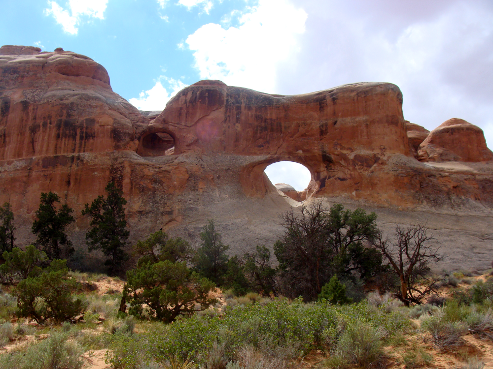
The next day we visited Arches National Park for the first time. Iconic for its incredible sandstone formations, particularly its astonishing natural arches as seen on calendars, desktops, and in stock photo archives everywhere, Arches is somehow so overexposed that it's hard to grasp the enormity of the intricate geological processes that bring these arcing sculptures to life. Here we stand, in the limelight of this sandstone's heyday, when millions of years of erosion have unlocked thousands of free standing arches for a brief eon of existence before they erode away like so much stone before them.


Even as a degree-holding geologist I have a hard time truly processing the cornucopia of factors that allow the arches to stand today. First you need to put a hefty deposit of porous sandstone on top of a denser, clayey layer that is already on top of a thick, salty layer, preferably left behind by an ancient ocean. Then you need the sediment on top of the salt to be just heavy enough that the salt liquefies, buckles, and causes uplift. You need this uplift to crack the uppermost sandstone layer; in this case that layer is the Entrada sandstone formation and the medium for most of the park's arches.
Once the Entrada sandstone cracks, you must wait a million years or more for just the right amount of rain to fall, eroding the cracks into deep yet narrow valleys. You need just the right amount of water to gather at the crux between the Entrada formation and the denser layer beneath. These puddles have to create cavities by dissolving the sandstone into loose particles and allowing it to be washed or blown away. One fine day, these cavities will become the famous gaps in the arches. But don't wait too long, because left to nature's erosional ways, the precariously crafted aches will eventually be washed of their cement and turned to dust too.


So you are here, on just the right day in not only your whole life, but in all of geologic history, to see these delicate arches stand - fragility and temporality encased in the feigned permanence of stone. Because without a doubt the arches will be gone one day, and perhaps that day might will tomorrow. Mother Nature can be a bitch like that. But I suppose she's an even more impressive as an artist, for who knows what other epic earth sculptures she has locked away and waiting for another million years or so to release.

After the mindfuck that is Arches, we hit the highway west for a less surreal landscape - at first glance. Fishlake National Forest may not carry the same shock and awe power that Arches does, but a glimpse underneath the soil tells a different story. What might be mistaken for just another forest thick with quaking aspen (Populus tremuloides) is actually an organism oft touted as the oldest, largest, and heaviest on the planet.
Can you guess what colossus lives in this Southeast Utah forest? Why, it's Pando, of course, and he is the forest! Pando is actually 160 acres of clonal quaking aspen, believed to be at least 80,000 years old and weighing upwards of 13 million pounds.


You might be wondering how one tree can be multiple organisms weighing millions of pounds, but all you have to know is that Pando isn't just one tree, he is all of the trees. He thrives from a singularly dense system of roots from which he sends up suckers that turn into saplings with the same biological and molecular make up as the trees from whose roots they sprang. Multiply this process by 80,000 years, maybe more, and you have a forest full of genetic clones all a part of the same root body: Pando, which translates from Latin into "I spread".

Scientists believe that Pando is the vestigial remains of an ecosystem from a much warmer climate and that due to unfavorable present day conditions, Pando hasn't flowered for 10,000 years. And whether this data translates into chilly September nights, I don't know, but Nessa and I surely found it difficult to do most things that brisk evening, including build a fire, which we failed miserably at. Damned damp Pando wood!! Though I suppose that's what you get when you road trip in September at 8,800 feet above sea level.
So we woke up a little cranky the next morning, arguing over who was pushing who into which puddle of freezing water pooling into the tent while sleeping, but like the intrepid travelers that we are, eagerly hit the road to lower elevations.
Actually, that isn't to be continued because I already posted my ode to that paranormal highway. So read it next and then stay tuned for a little ditty I like to call "Morning Over Mono".