March 23, 2013

Bonneville Salt Flats and The Great Salt Lake

 photo DSC04145_zps033e90d3.jpg

(View from the Great Saltair.)

One of my most favorite places on the planet (so far) is the Bonneville Salt Flats and the Great Salt Lake, west of Salt Lake City, Utah. It is two of my favorite location features in one: flat and salty! The salt flats and the Great Salt Lake behave like a lot of places on my Bucket List, because after finally visiting it, it became a place I had to visit again and again and as many times as possible. So far, I have been there twice.

Great Salt Lake crossing
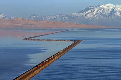
("An eastbound Union Pacific freight begins the long trek across Great Salt Lake at Lakeside, Utah. A wood trestle used to carry the line straight across directly in front of the train, but was later replaced with the fill that now zig-zags to the north. Promontory Peninsula and the Wasatch Mountains dominate the background, with Ogden located between them.")
Credit: Mike Danneman
 
The Bonneville Salt Flats are famous for a number of things. Firstly, it is the site of ancient Lake Bonneville that covered much of the Great Basin area. The ancient lake and the subsequent flood that emptied it are responsible for the remarkably unique geology. Secondly, it is widely known as the venue for setting land-speed records, as the land is so flat and expansive, it is the only place on earth where you can see the curvature of the earth.

(Map showing Pleistocene lakes in northwestern United States.)

 photo DSC04008_zps1f8c058b.jpg
(Bonneville International Speedway Entrance... covered in water!)

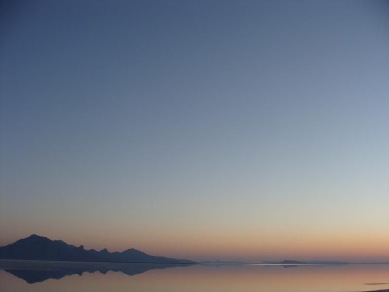
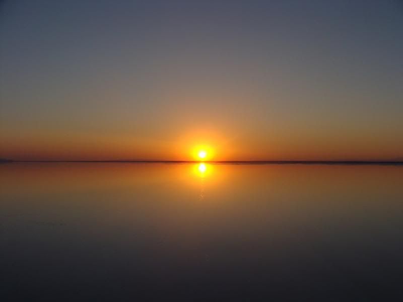
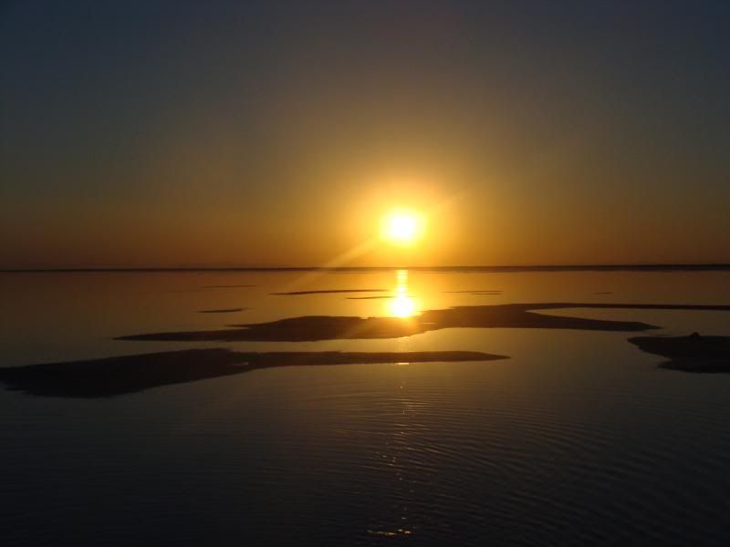
Thirdly, it is one of the most amazing places in the country to see the sunrise! The first time I was able to visit was in 2011 with my roadtrip girl troop. At this point, I wasn’t privy to the “Bend in the Road”, where there is permissible camping as well as access to the flats with your car. We silly girls camped the night at a KOA in Wendover, Nevada (not my favorite place in the world), woke up super early and drove to an eastbound rest area and then hiked across I-80 with camp chairs and pillows to await the rising sun. We were not disappointed!

 photo DSC02092_zps46b44ec8.jpg  photo DSC02102_zps48852963.jpg

The second time I was able to visit the Salt Flats was this summer’s end. After AGP flew from Reno, Nevada, I was bound for South Dakota, and right past the Salt Flats to boot! I was surprised to find a thin layer of water stretching as far as I could see over the salt and that it was otherwise muddy, and not being brave enough to camp on the mud by myself, I chose to spend the night in Wendover (again), but this time at a hotel. I rose early and this time hit up the Bend in the Road for a spectacular experience.

 photo DSC04030_zpsd4e2f0ad.jpg  photo DSC04052_zps85540ec3.jpg  photo DSC04086_zpse98e2fe2.jpg 

Amazing!!!! The Great Salt Lake gets its high salinity as an endoheric lake, meaning that it has no outlets for water except for evaporation. Its extra saltiness makes it uninhabitable for all but brine shrimp and brine flies, which in my experience means water wriggling with sea monkeys and buzzing with flies. It probably isn’t for those whom insects cause a faint heart. I, on the other hand, would happily swim cheek-to-cheek with sea monkeys any day (and the second time I was there, there were way less creatures around).

  photo DSC04154_zps100385b6.jpg 

 I have accessed the shore of the Great Salt Lake from the exit off of I-80 that takes you to the Great Saltair music venue. From there, I take the muddy hike to the water’s edge, then the great salty plunge! Just kidding, as the lake is approximately 33 feet at its very deepest, it takes quite a lot of wading through sea monkeys and breathing brine flies before you can get even knee deep. And as a matter of fact, I don’t recommend actually plunging or you will get a burning face full of salt!

 photo DSC04146_zps164fa17f.jpg
(The Great Saltair)

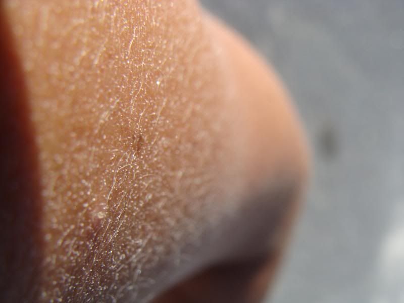
However, you are rewarded for your efforts by a pleasant float. That’s right, the water, being saltier than seawater, affords an experience unique to our world’s saltiest lakes—you can almost sit cross legged right on the water’s surface! At the very least, you will have an effortless floating experience, far from the noise of I-80 and those possibly waiting for you at the water’s muddy edge: just you and the (hopefully) blue skies, and occasionally sharing space with happy hoards of sea birds gobbling up brine flies. And, as you begin the hike back to your car, the most amazing phenomenon will start to occur on your skin. As the water on you starts to dry and evaporate, a thin and beautiful layer of salt will start to crystallize on you, coating your arm hair and leaving you glistening with nature’s delicious glitter. This is one of the few times when I can agree with the philosophy, the hairier the better!

 photo DSC04141_zps501e771b.jpg
(Evaporated salt crystals!)

 photo DSC04170_zps3e9dc92c.jpg

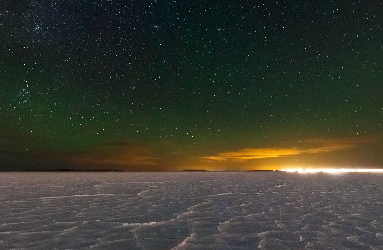
The Great Saltair has complementary outdoor showers you can use to shed some of your salty glitter, although the last time I was there, the showers were off for the sake of the nearby sprinklers. It was really no matter, as I quickly improvised with the sprinklers. Next time I am in the area of the Great Salt Lake, I would love to take some time to explore more areas of the lake’s coast, and perhaps drive my car deep into the salt flats until I disappear over the curve of the earth. If you have the time, take a break with this 3D panorama of the Salt Flats at night brought to you by Utah 3D. I want to be there like crazy!!!

 photo 3dpan_zps6da52a75.png

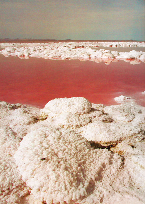
Antelope Island is a State Park that has hiking trails, and I would love to explore some oolitic sands (pearl-ish grains of calcium carbonate precipitated around a nucleus) and maybe search for lake monsters. I have also never seen the Spiral Jetty, Robert Smithson’s land art installment (1970), made of local basalt rocks (now covered with salt evaporate) and located in an area where the water looks red. The Spiral Jetty is only visible when the water level drops to an appropriate level. However, check out this beautiful picture I came across online… so salty and pink!

 
Robert Smithson, Spiral Jetty Detail, 1970 

Is there anybody out there that has any suggestions or love of the Great Salt Lake and/or Bonneville Salt Flats to share?

March 20, 2013

Go: Colo-Rockin'

(Welcome back! It now time for me to briefly recount my first time in Colorado (not counting the Four Corners). Please forgive me for the lack of vivid detail and photos, read on to be reminded why...)

 photo colorockin_zpsdf24ad6a.png

The most unfortunate thing started to happen as we left Oklahoma and headed to Colorado. AGP’s itchy throat and slight fatigue that had been plaguing him as we explored the panhandle got progressively worse, and by the time we reached Boulder, it had turned into a case of double pink-eye!! I won’t mention any of the gruesome details because he would probably get embarrassed, so I will just assure you that once we finally realized that it was what it was, we were able to clear it up in a few days (and that I was blessedly left uninfected).
 photo IMG_9626_zps9399f278.jpg  photo IMG_9622_zps3f98da8c.jpg  photo IMG_9635_zps95129c04.jpg

After our hike up Black Mesa, we cruised across the northeast-most traversable part of New Mexico and into Colorado toward Lake Trinidad, where we going to spend the night. We were treated with our first view of the menacing Rocky Mountains towering over us and some other things yet un-experienced. 

 photo DSC03833-Copy_zps361b8892.jpg  photo IMG_9652_zpsd773f412.jpg

Now, I have heard tell of how awesome the winds of the prairie are, how they sweep mercilessly and unrelenting day and night, their roar deafening you as you sit trembling in your home, yet all across Oklahoma we were treated to calm, peaceful nights and days. This was not so at Lake Trinidad, where we sat at a precariously high elevation above the lake and the winds whipped frighteningly at our tent to the point where we had it anchored down with at least fifteen ropes. We had to eat very quickly and then hide in the tent the whole night and hope that we didn’t end up blowing away! To bad you can't really tell how hard the wind was blowing from the pictures! 

 photo IMG_9645_zpse589d0e4.jpg  photo IMG_9655_zps4443ff85.jpg

We did a little exploring in the morning, but were otherwise on the way up I-25 to Boulder to meet up with some of AGP’s family who had agreed to host us for the weekend. AGP spent a semester at UC: Boulder a few years ago and was excited to show me some of the things he fondly remembered. Sadly, the case of double pink-eye held us back a little. We did enjoy a swim at the creek, the nightlife in downtown Boulder, and some wonderful live music in between nap times and recovery periods. And I enjoyed meeting some more of AGP’s quirky family. Oh and check out these amazing pictures of the area in Boulder the family lived-- only a few years ago, a massive wildfire destroyed the mountaintop, mercifully sparing their home. It is estimated that the nearby ridges will remain barren for the next 50 years:
  photo DSC03842_zps43df1d5c.jpg
(What it should look like.)
 photo DSC03841_zps1dc6ccd0.jpg
(What it does look like.)

Wild! After we left Boulder, we were heading northbound towards South Dakota, where we had agreed to WWOOF at an organic vegetable farm mid-June. So when we left Boulder, we headed east again. We had sadly forfeited our chance to cross Rocky Mountain National Park off my bucket list to the pink-eye, but as I was nearly sick with excitement from exploring Nebraska, it seemed a small price to pay for AGP being well again and me getting enough time in the Cornhusker state. 

If you aren’t yet hip to my strange love of flat, unpopular regions, I will pre-empt the next chapter of my story with the note that: I unsurprisingly loved western Nebraska so much that once we were done with the trip and I was on my way back east, I drove miles out of my way to visit western Nebraska again! 

Here is Colorado according to us: 

 photo colo_zpsf5c9cbdf.jpg

A: Black Mesa State Park, Kenton, Oklahoma 
B: Lake Trinidad State Park, Trinidad, Colorado 
C: Boulder, Colorado 
D: Lake Minatare, Scottsbluff, Nebraska 

The reasons I adore Nebraska will be illuminated if you stay tuned for Go: Zy loves Nebraska.

~~

Want to catch up with all of 'Go'?
Go: Intro
Go: Cloudy, With A Chance of Death From Above
Go: Okla-home

March 11, 2013

Go: Okla-home

(Hi All- I am back with another exciting installment of 'Go' (Follow the link to the last chapter)... where do AGP and I find ourselves now? Oklahoma!)

 photo gooklahome_zps157d1402.png

As our friends headed east towards home, we headed just a little bit north in order to go straight west- all the way across Oklahoma, into the panhandle, and then right out the other side!

 photo IMG_9492_zps387ebd23.jpg

Oklahoma is a state that I have long wanted to explore, kind of like the way I felt about Arkansas. I knew I would love it- long, grid-like roads cutting through miles of wheat and faded nothingness- have you ever seen Twister? Absolutely one of my top five movies. Plus, before the trip, I tore through Prairie Women: Women of the Kansas Frontier (Joanna Stratton) and The Worst Hard Time: The Untold Story of Those Who Survived the Great American Dust Bowl (Timothy Egan). I recommend both of those very highly if you are interested at all in frontier life or the dust bowl. I was definitely prepped as we headed onto the prairie.

We cleaned up from our festival debaucheries at Kettle Campground in Eureka Springs, Arkansas, another town famous for its groundwater. Our trip had finally begun!! We still had a lot of technical things to work out regarding the packing method of our car and general campsite set up, so we spent the evening unpacking, cleaning, and finding a home for everything. The next morning we took a small side trip through the unique village of Eureka Springs, which has distinct curving streets with stores that have street level entrances on more than one floors. Then we hunted around for magically healing groundwater springs, took a quick trip up the fire tower to catch a glimpse of Christ of the Ozarks and a stop at the Thorncrown Chapel, an architectural jewel designed by E. Fay Jones.

 photo IMG_9331_zps8a4d6264.jpg  photo DSC03680_zpse304b7dc.jpg  photo DSC03671_zpsc3da8918.jpg  photo IMG_9358_zpse9dfb9e2.jpg

And then Oklahoma at last! We hit the highway out of Fayetteville, AR towards Tulsa, OK and then jumped up into the Osage Nation to Pawhuska (home of the Pioneer Woman!). The small towns that we passed through really captured the essence of life on the remote plains. As a girl who grew up in the prolific suburbs between Boston and New York, it was strange to find myself in a supermarket devoid of fresh meat and with the produce selection of a corner bodega in the city (I would later learn in South Dakota that I was in what is called a “Food Desert”: despite miles of farmland, none of it was being dedicated for human consumption and with little to no access to grocery stores). In all of my travels across the United States and northern Canada had I yet to come across such isolated towns whose historic significance had all but faded away. (And please don’t think that I am trying to discount the personal significance that of course still bolsters each unique community!) Naturally, I was enraptured. I could have spent the whole summer crisscrossing Oklahoma, living off of kielbasa and frozen vegetables if I had to.

 photo DSC03783_zps80f62923.jpg

Our first stop was the Great Salt Plains Lake State Park, north-central Oklahoma, famous for two things: red sandstone cliffs and… well, the second thing I am going to keep that a secret for now! (Geology buffs should start getting excited!) Our campsite at the state park was not entirely secluded (abutted the only neighborhood in town), but was right on the lake edge and never mind that we didn’t see or hear from anybody the whole night. It was pretty sweet. Even better, the night was alive with cicadas! And I don’t just mean singing from the trees, but alit in a way that might be considered a swarm by those sensitive to insect proximity. Cicadas are clumsy and harmless, and extremely fun to chase around with sticks. Just a little tap and out of the air they fall. (Absolutely no harm was caused to any of the cicadas who were involved in my game… they seemed notorious for flying straight into things (read: faces, trees, parked cars) and falling on the ground anyway).

 photo DSC03723_zps7ffd2ea3.jpg  photo DSC03730_zpsc6d7f5e4.jpg  photo DSC03735_zps87365f75.jpg
(Brussels sprouts for breakfast? Yes, please!)

We also consider ourselves extremely fortunate to have been witnesses to a remarkable celestial event that happened to occur the exact moment we were star-gazing over the lake. On that night, June 5th, at around 10pm, we were treated to a bolide meteor fireball! It was a like a green shooting star, bigger than anything I have ever seen in the sky!! Truly an extraordinary event. Since we obviously didn’t get a photo of the fireball, enjoy some pictures of us playing with our headlamps and imagine they are meteors streaking through the sky:

 photo IMG_9438_zps8c8134c1.jpg  photo IMG_9437_zps79df2be1.jpg  photo IMG_9428_zpse0845b58.jpg  photo IMG_9443_zpscd889f15.jpg

In the morning, before we left for the panhandle, we made a quick stop on the opposite side of the lake to do a little gem-hounding and satisfy the trained geologist inside of me. Yay! What I was keeping a secret was that the Great Salt Plains Lake is a mine for hourglass selenite crystals, which are unique to only this locale and completely free and easy to gather. Selenite is a form of crystallized gypsum, which when combined with the clay sediment from the Great Salt Plains Lake, form a unique hourglass shape inside. I gathered quite a few that chilly, wind-swept morning, and had such a good time (between that and the cicada chasing) that I would absolutely make a point to return to the Great Salt Plains Lake on a future trip. The following are a few pictures of me having a blast digging in the salty mud for crystals:

 photo IMG_9455_zpsf5f20e97.jpg  photo IMG_9457_zps096e9a00.jpg  photo DSC03763_zpsd671f9a5.jpg

Our goal for the day was to make all the way to the western point of the panhandle. We cruised aimlessly around a bit to try to catch a glimmer of Gloss Mountain, which is also known for its high selenite content that makes the mountains shimmer like glass, and then we took a quick visit to the Sod House Museum in Aline.

 photo DSC03746_zpsbbfe0bfe.jpg  photo DSC03741_zps507a549d.jpg
(It was overcast while we passed Gloss Mountain so we didn't get to see very much glimmer!)

Then we entered the heart of the dust bowl! Amazingly, we could even still see the old drifts of dust built up around surviving fences from that time. Most impressive were the power lines that stretched the entire 200-mile span, bringing power into the lives of the people in towns like Guymon and Boise (pronounced like boy) City. And Boise, was it flat (I’m so funny!). Technically, the panhandle of Oklahoma is flatter than a pancake! We had a good time on the flat, quiet roads, just us and the waving wheat.

 photo IMG_9490_zps35f4c023.jpg  photo DSC03773_zps069954db.jpg  photo IMG_9496_zpsfa790758.jpg

We made it all the way to the state park that contains Black Mesa, which at 4,973ft is the highest point in Oklahoma, and lies at the westernmost edge of Oklahoma and dust bowl territory. Today, it is a state park that marks where the Rocky Mountains meet the short-grass prairie. We took a day hike up to the peak through the land of black lava rock and spotted with juniper and cholla cacti.

 photo DSC03798_zpsb9228b80.jpg  photo IMG_9576_zpsfe42349e.jpg  photo IMG_9598_zps62051841.jpg  photo IMG_9589_zps891b6be8.jpg  photo IMG_9614_zpsab98370f.jpg
(Oh yea, then we got to see some fossilized dinosaur footprints!! Though it might be hard to imagine, those aren't muddy puddles, but exposed mudstone with perma-dino tracks!)

Ah, Oklahoma. I was greatly impressed with my trip there. Despite its reputation and lack of obvious attractions for those from the crowded east coast, each day was long, eventful, and informative. Oklahoma plays an immense role in our country's history and I am grateful for those who endured the hardships then and now. Even now as I recollect, I long to be back to the flat, golden lands, sneaking with cacti and a-buzz with desert life. Maybe I could have been an effective pioneer, had I been given the cosmic chance!
 photo IMG_9535_zps8ce74a82.jpg

Here is this chapters route-- so much happened in two days!:
  photo mapok_zps65ccf95f.png

A: Eureka Springs, Arkansas
B: Great Salt Plains Lake, Alfalfa, Oklahoma
C: Black Mesa State Park, Kenton, Oklahoma

[Follow this blog for more adventures!]

After the break, follow along as AGP and I head into Colorado in
Go: Colo-rockin’