May 1, 2013

Go: Nebraska!


It was (I imagine) a typically windy day in Nebraska as we crossed the state lines from a brief jaunt in Wyoming. For those of you reading who aren’t familiar or yet aware, this demarcation means a heck of a whole lot to me:


Why do I feel this good about entering the Cornhusker state? Because it is the first time ever that I am visiting Nebraska and I am ever so excited about what is in store. 

We entered Nebraska heading east on Route 88 towards Scottsbluff as the day was rolling towards its close. After scoping out a possible campsite in the Wildcat Hills State Recreation Area (and deciding it was a little bit too hot, windy, and exposed for our tastes), we headed on to Lake Minatare to endure yet another windy night at camp. We attempted to set up a wind-break for our tent, but mostly just ended up looking like foolish, non-natives trying to catch some wind with our tarp sail.

In the art of campfire cooking, I am a Master.


Before leaving the next morning, we checked out Lake Minatare’s unique feature, its lighthouse—in fact, it is the only lighthouse in Nebraska! Which makes sense, considering Nebraska is landlocked and probably has little need for anymore!

Lake Minatare
The lighthouse of the prairie!
Cassin's Kingbird
And then it was on into the grasslands with my heart a-flutter at the flat awesomeness of it all. Yes, you should realize by now that I am a total weirdo when it comes to flat expanses of land, probably dominated by some sort of monoculture or at the very least, grass. I especially love driving for hours on end through the rural heart of it, daydreaming about something-or-other while gazing out the window trapped in field-hypnosis and feeling totally at peace with myself. 

View of the Pine Ridge in the background...
Our first stop was the Agate Fossil Beds National Monument in northwestern Nebraska, famed for its well-preserved Miocene (over 20 million years ago!) fossils and an incredible Lakota Sioux museum of artifacts collected and preserved by the Monument's previous owner, James Cook. We took a short tour of the site and saw some incredible fossils, including the Daemonelix, a fossilized, corkscrew shaped burrow dug by the land beaver, Palaeocastor.
 
Agate Fossil Beds National Monument
Prickly Poppy
Daemonelix

We dipped north into the Oglala National Grasslands, a 94,520 acre preserve of our nation’s most endangered and dwindling natural habitat, towards Toadstool Geologic Park where we were planning on spending the night. While many of you who will find and read this blog may never make western Nebraska one of your travel destinations, Toadstool Geologic Park has been one of the most spectacular natural destinations I have encountered in my travels. The campsite, situated at the base of the badlands-toadstool formations on the edge of the grasslands is not only affordable, but offers amazing hiking opportunities, not only into the geologic heart of the park, but also to the Hudson-Meng BisonKill excavation and archaeological dig site (which we hiked to, but could not enter because we forgot our wallets!!).

Sod house at the campground with a roof cactus!
View of the Toadstool campground

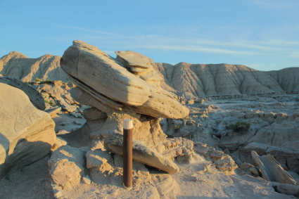
Why do these rocks look the way they do? Toadstool Geologic Park is situated at the southern edge of the Badlands formation, the largest of these formations being preserved in the Badlands National Park near Wall, South Dakota, about 100 miles to the northeast. In these geologic areas, the soft, sedimentary rocks have been eroded away by water and wind to form magnificently colored gullies, peaks, and spires. While this small section of Nebraskan badlands are not as pronounced and expansive as the South Dakotan badlands, Toadstool gets its name from some particularly quirky formations that look like, you guessed it, mushrooms!
 

After getting our fill of toadstools, grasslands, and bison kills, AGP and I headed evermore north into South Dakota. Such adventure and magic awaited us that I became inexorably entwined with the state, the environment, and the people here, that I have visited a number of times since... more on that later.

Here is the map of our Nebraskan adventures:


A: Boulder, Colorado
B: Lake Minatare State Park, Scottsbluff, Nebraska
C: Agate Fossil Beds National Monument, Nebraska
D: Toadstool Geologic Park, Nebraska

Ever so shortly, AGP and I will be entering the magical state of South Dakota, so stay tuned!

March 23, 2013

Bonneville Salt Flats and The Great Salt Lake

 photo DSC04145_zps033e90d3.jpg

(View from the Great Saltair.)

One of my most favorite places on the planet (so far) is the Bonneville Salt Flats and the Great Salt Lake, west of Salt Lake City, Utah. It is two of my favorite location features in one: flat and salty! The salt flats and the Great Salt Lake behave like a lot of places on my Bucket List, because after finally visiting it, it became a place I had to visit again and again and as many times as possible. So far, I have been there twice.

Great Salt Lake crossing
("An eastbound Union Pacific freight begins the long trek across Great Salt Lake at Lakeside, Utah. A wood trestle used to carry the line straight across directly in front of the train, but was later replaced with the fill that now zig-zags to the north. Promontory Peninsula and the Wasatch Mountains dominate the background, with Ogden located between them.")
Credit: Mike Danneman
 
The Bonneville Salt Flats are famous for a number of things. Firstly, it is the site of ancient Lake Bonneville that covered much of the Great Basin area. The ancient lake and the subsequent flood that emptied it are responsible for the remarkably unique geology. Secondly, it is widely known as the venue for setting land-speed records, as the land is so flat and expansive, it is the only place on earth where you can see the curvature of the earth.

(Map showing Pleistocene lakes in northwestern United States.)

 photo DSC04008_zps1f8c058b.jpg
(Bonneville International Speedway Entrance... covered in water!)

Thirdly, it is one of the most amazing places in the country to see the sunrise! The first time I was able to visit was in 2011 with my roadtrip girl troop. At this point, I wasn’t privy to the “Bend in the Road”, where there is permissible camping as well as access to the flats with your car. We silly girls camped the night at a KOA in Wendover, Nevada (not my favorite place in the world), woke up super early and drove to an eastbound rest area and then hiked across I-80 with camp chairs and pillows to await the rising sun. We were not disappointed!

 photo DSC02092_zps46b44ec8.jpg  photo DSC02102_zps48852963.jpg

The second time I was able to visit the Salt Flats was this summer’s end. After AGP flew from Reno, Nevada, I was bound for South Dakota, and right past the Salt Flats to boot! I was surprised to find a thin layer of water stretching as far as I could see over the salt and that it was otherwise muddy, and not being brave enough to camp on the mud by myself, I chose to spend the night in Wendover (again), but this time at a hotel. I rose early and this time hit up the Bend in the Road for a spectacular experience.

 photo DSC04030_zpsd4e2f0ad.jpg  photo DSC04052_zps85540ec3.jpg  photo DSC04086_zpse98e2fe2.jpg 

Amazing!!!! The Great Salt Lake gets its high salinity as an endoheric lake, meaning that it has no outlets for water except for evaporation. Its extra saltiness makes it uninhabitable for all but brine shrimp and brine flies, which in my experience means water wriggling with sea monkeys and buzzing with flies. It probably isn’t for those whom insects cause a faint heart. I, on the other hand, would happily swim cheek-to-cheek with sea monkeys any day (and the second time I was there, there were way less creatures around).

  photo DSC04154_zps100385b6.jpg 

 I have accessed the shore of the Great Salt Lake from the exit off of I-80 that takes you to the Great Saltair music venue. From there, I take the muddy hike to the water’s edge, then the great salty plunge! Just kidding, as the lake is approximately 33 feet at its very deepest, it takes quite a lot of wading through sea monkeys and breathing brine flies before you can get even knee deep. And as a matter of fact, I don’t recommend actually plunging or you will get a burning face full of salt!

 photo DSC04146_zps164fa17f.jpg
(The Great Saltair)

However, you are rewarded for your efforts by a pleasant float. That’s right, the water, being saltier than seawater, affords an experience unique to our world’s saltiest lakes—you can almost sit cross legged right on the water’s surface! At the very least, you will have an effortless floating experience, far from the noise of I-80 and those possibly waiting for you at the water’s muddy edge: just you and the (hopefully) blue skies, and occasionally sharing space with happy hoards of sea birds gobbling up brine flies. And, as you begin the hike back to your car, the most amazing phenomenon will start to occur on your skin. As the water on you starts to dry and evaporate, a thin and beautiful layer of salt will start to crystallize on you, coating your arm hair and leaving you glistening with nature’s delicious glitter. This is one of the few times when I can agree with the philosophy, the hairier the better!

 photo DSC04141_zps501e771b.jpg
(Evaporated salt crystals!)

 photo DSC04170_zps3e9dc92c.jpg

The Great Saltair has complementary outdoor showers you can use to shed some of your salty glitter, although the last time I was there, the showers were off for the sake of the nearby sprinklers. It was really no matter, as I quickly improvised with the sprinklers. Next time I am in the area of the Great Salt Lake, I would love to take some time to explore more areas of the lake’s coast, and perhaps drive my car deep into the salt flats until I disappear over the curve of the earth. If you have the time, take a break with this 3D panorama of the Salt Flats at night brought to you by Utah 3D. I want to be there like crazy!!!

 photo 3dpan_zps6da52a75.png

Antelope Island is a State Park that has hiking trails, and I would love to explore some oolitic sands (pearl-ish grains of calcium carbonate precipitated around a nucleus) and maybe search for lake monsters. I have also never seen the Spiral Jetty, Robert Smithson’s land art installment (1970), made of local basalt rocks (now covered with salt evaporate) and located in an area where the water looks red. The Spiral Jetty is only visible when the water level drops to an appropriate level. However, check out this beautiful picture I came across online… so salty and pink!

 
Robert Smithson, Spiral Jetty Detail, 1970 

Is there anybody out there that has any suggestions or love of the Great Salt Lake and/or Bonneville Salt Flats to share?

March 20, 2013

Go: Colo-Rockin'

(Welcome back! It now time for me to briefly recount my first time in Colorado (not counting the Four Corners). Please forgive me for the lack of vivid detail and photos, read on to be reminded why...)

 photo colorockin_zpsdf24ad6a.png

The most unfortunate thing started to happen as we left Oklahoma and headed to Colorado. AGP’s itchy throat and slight fatigue that had been plaguing him as we explored the panhandle got progressively worse, and by the time we reached Boulder, it had turned into a case of double pink-eye!! I won’t mention any of the gruesome details because he would probably get embarrassed, so I will just assure you that once we finally realized that it was what it was, we were able to clear it up in a few days (and that I was blessedly left uninfected).
 photo IMG_9626_zps9399f278.jpg  photo IMG_9622_zps3f98da8c.jpg  photo IMG_9635_zps95129c04.jpg

After our hike up Black Mesa, we cruised across the northeast-most traversable part of New Mexico and into Colorado toward Lake Trinidad, where we going to spend the night. We were treated with our first view of the menacing Rocky Mountains towering over us and some other things yet un-experienced. 

 photo DSC03833-Copy_zps361b8892.jpg  photo IMG_9652_zpsd773f412.jpg

Now, I have heard tell of how awesome the winds of the prairie are, how they sweep mercilessly and unrelenting day and night, their roar deafening you as you sit trembling in your home, yet all across Oklahoma we were treated to calm, peaceful nights and days. This was not so at Lake Trinidad, where we sat at a precariously high elevation above the lake and the winds whipped frighteningly at our tent to the point where we had it anchored down with at least fifteen ropes. We had to eat very quickly and then hide in the tent the whole night and hope that we didn’t end up blowing away! To bad you can't really tell how hard the wind was blowing from the pictures! 

 photo IMG_9645_zpse589d0e4.jpg  photo IMG_9655_zps4443ff85.jpg

We did a little exploring in the morning, but were otherwise on the way up I-25 to Boulder to meet up with some of AGP’s family who had agreed to host us for the weekend. AGP spent a semester at UC: Boulder a few years ago and was excited to show me some of the things he fondly remembered. Sadly, the case of double pink-eye held us back a little. We did enjoy a swim at the creek, the nightlife in downtown Boulder, and some wonderful live music in between nap times and recovery periods. And I enjoyed meeting some more of AGP’s quirky family. Oh and check out these amazing pictures of the area in Boulder the family lived-- only a few years ago, a massive wildfire destroyed the mountaintop, mercifully sparing their home. It is estimated that the nearby ridges will remain barren for the next 50 years:
  photo DSC03842_zps43df1d5c.jpg
(What it should look like.)
 photo DSC03841_zps1dc6ccd0.jpg
(What it does look like.)

Wild! After we left Boulder, we were heading northbound towards South Dakota, where we had agreed to WWOOF at an organic vegetable farm mid-June. So when we left Boulder, we headed east again. We had sadly forfeited our chance to cross Rocky Mountain National Park off my bucket list to the pink-eye, but as I was nearly sick with excitement from exploring Nebraska, it seemed a small price to pay for AGP being well again and me getting enough time in the Cornhusker state. 

If you aren’t yet hip to my strange love of flat, unpopular regions, I will pre-empt the next chapter of my story with the note that: I unsurprisingly loved western Nebraska so much that once we were done with the trip and I was on my way back east, I drove miles out of my way to visit western Nebraska again! 

Here is Colorado according to us: 

 photo colo_zpsf5c9cbdf.jpg

A: Black Mesa State Park, Kenton, Oklahoma 
B: Lake Trinidad State Park, Trinidad, Colorado 
C: Boulder, Colorado 
D: Lake Minatare, Scottsbluff, Nebraska 

The reasons I adore Nebraska will be illuminated if you stay tuned for Go: Zy loves Nebraska.

~~

Want to catch up with all of 'Go'?
Go: Intro
Go: Cloudy, With A Chance of Death From Above
Go: Okla-home